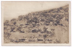
[Editor: This postcard (unused), which incorporates a photo of military dug outs on a hillside, is from the era of the First World War (1914-1918). The postcard is undated.]
Dug outs at Anzac Cove (Dardanelles)
[Front of postcard]
Dug outs at Anzac Cove (Dardanelles)
[Photo of military dug outs (in this instance, primarily tents and awnings dug into a hillside) at Anzac Cove, on the Gallipoli peninsula.]
[Reverse of postcard]
Post card.
Hunt London
The British photo post card
Philip G. Hunt & Co. 332 Balham High Road
London. S.W.
Printed in England
Source:
Original document
Editor’s notes:
Dimensions (approximate): 138 mm. (width), 88 mm. (height).
Anzac Cove = a cove on the western coast of the Gallipoli peninsula (part of the section of Eastern Europe held by Turkey), located on the European side of the Dardanelles strait; where the Australian and New Zealand Army Corps (ANZAC) landed and fought against the Turkish army in 1915
Dardanelles = (also known as the Strait of Gallipoli) the strait which connects the Sea of Marmara (north-west end of the strait) with the Aegean Sea (south-east end of the strait), the latter of which connects to the Mediterranean sea; it is bounded on its northern side by the Gallipoli peninsula and on its southern side by the mainland of Turkey; it is considered to be part of the continental boundary between Asia and Europe (thus separating Asian Turkey from European Turkey); it was the site of a military campaign during the First World War, when the Allied powers attacked the Gallipoli peninsula (part of Turkey) in 1915
Gallipoli = the Gallipoli peninsula (in western Turkey), which is located in the southern part of East Thrace, the European part of Turkey; it was the scene of heavy fighting during the Gallipoli Campaign (February 1915 to January 1916), during the First World War (1914-1918); running along the eastern coast of the Gallipoli peninsula is the Strait of Gallipoli, also known as the Dardanelles (or, the Dardanelles strait)


Leave a Reply